Ceci n’est pas un nuage
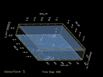
The first movie depicts the cloud field (the grayish bubbles) with a range of shallow cumulus (the little guy near the ground), nimbo-cumulus (the so-called convective towers) topped by their anvil clouds (the cirrus clouds near the tropopause.). The color surface at the bottom shows the vertical velocity at 200m. Blue region corresponds to downward motions, and red corresponds to ascent. Notice the spreading blue regions after a deep convective clouds. These are the cold pools, where colder air from the mid troposphere has been brought down by a downdraft and spreads near the surface. Also, at the edge of the cold pool, there is a ring of ascending motion. If you look carefully, you would notice that the next convective tower will often start at the edge of the cold pool, where the air has just been kicked upward...
Eye Candy
I could not resist - I had to put these movies on the web...
They are based on data from high-resolution simulations of deep convection. You see a 120km by 120km atmospheric domain. The cirrus clouds here reach an altitude of 12-13km. In order to get the movie, you need to click on the corresponding images. Be warned, each file is fairly big (~5Mb).
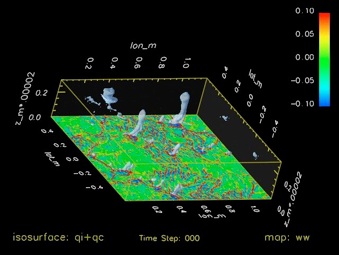
The second movie also shows the same cloud field, but now the coloring corresponds to the moist entropy distribution at 1200m. Entropy is that weird quantity in Clausius’ formulation of the second law of thermodynamics. In atmospheric sciences, it is also a very good measure of the ‘heat’ content of an air parcel. For the record, entropy is measured in Joules per Kelvin per kg (J/K/kg). The red coloring corresponds to air with a high entropy of 240J/K/kg or more. This is the warm, moist air from the surface that fuels the deep convection. The blue region is air with a very low entropy. These air parcels come from the mid troposphere, and their low entropy is primarily due to the fact that they are very dry. You can observe that convection has trouble crossing this layer of dry air, so that the deep convective towers occur preferentially within the green/red region where the lower troposphere is relatively moist.
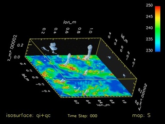
The third movie shows the evolution for the 235 J/K/kg isentropic surfaces. The thermodynamic structure of the tropical atmosphere is a bit odd, with a minimum of entropy sitting near 4-5km. As a result, the 235 entropy unit surface is folded, with one branch near the surface, and another near the tropopause. Deep convection shows up as a serie of ‘convective pipes’ that connect the lower portion of the isentropic surfaces to the upper portion. This illustrates the fact that the cumulus nimbus are fed by the high entropy air near the surface that rises all the way to the tropoause. You can also see the very strong asymmetric in moist convection in that these ‘convective pipes’ always form up from the bottom-up, never from the top-down. (For the experts, this is very different from the classic Rayleigh-Bénard convection, which is symmetric for a vertical flip.)